Bungonia Gorge Red Track

Image 1 - the magnificent Bungonia National Park, This image looking down to the Shoalhaven River from the ridge line near Mt Ayre
August 2017
This is a difficult walk, but if you are up to it physically, you are rewarded with magnificent views. The limestone slot canyon at the bottom section is a spectacular sight.
Walk Rating: Difficult. The red track at Bungonia National Park is rated as a level 5 walking track. Although only listed as 3.5 kilometres, there are extremely steep descents and ascents, and once on the gorge floor, you have to climb over and through huge limestone boulders. WARNING: You also need to be very cautious, as it is very easy to take the wrong track, many of which lead to cliff faces.
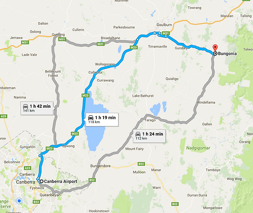
Directions: To get to the Bungonia National Park from Canberra, we took Kings Highway to Bungendore and then onto Tarrago. From Tarrago, follow the road signs to the town of Bungonia, and drive through the town where you will see a turn-off (signposted) to the right, which takes you to Bungonia National Park - it's only 10 kilometres from the town to the park entrance). Total distance was just over 112 kilometres and took us 1 hour 30 minutes. If you want to go through Goulburn (we came home that way), total distance is 118 kilometres and about five minutes quicker. See maps on right (note that measurement taken from Canberra Airport).
The Walk: As an avid bushwalker, the Bungonia Gorge has always been on my to do list. Not so I could simply 'tick it off', but because I genuinely wanted to do this walk as it presents some of the most spectacular scenery in Australia.
I'd been to Bungonia National Park as a kid with my parents, but my memories were only off the panoramic views from the viewing platforms. This time, I wanted to tackle the notorious 'red track'. Well...it's probably not really notorious, but it does have a reputation befitting the difficulty rating that it's been given by NSW Parks.
After arriving at the National Park, we stopped into the Rangers Office and signed in. There is an $8 fee for car parking, but I like to think that this money goes back into maintaining the National Park rather than just pure revenue raising. Best to have the right change, as the day we went, the office was unattended and we had to put the money into an envelope and drop it into the wall slot.
After dispersing with this formality, we drove a short distance further and on the right side is the carpark, and the start of the red walking track. It's also linked into the green and white walking tracks.
We parked our car and had a quick look at the information board, which contains some interesting information about the park, as well as an enlarged map showing the various walking trail routes (Image 2).


After slinging our packs and carrying-out a last minute check to make sure we had all our gear, we set off across the road to where the start of the red track was. You will also return to the this carpark at the end of the walk (from a different direction) as the red track intersects with the white and green and both bring you back to the carpark.
I have read that there is a bit of debate as to whether you do this walk clockwise or counter clockwise. Having never done the walk before, we set off where the 'official' start of the walk was, so our direction was clockwise (Images 3 and 4).
The walk starts off very pleasantly and you follow a creek line, which winds around to its eastern side, where the track starts to narrow. At this point, you start to appreciate how steep the descent will be as the views to the gorge start to open up, and you get an appreciation for how far below the actual walking track will take you.
Image 2 - The carpark and information board near the start of the red track


Image 3 (above left) and Image 4 (above right) showing the start of the red walking track. Taking this route means you will do the walk in a clockwise direction
As you walk along the track, you will come to a star picket with a red tip (Image 5). NOTE: This does not mean you are on the right track! This means you have to turn left (which we wouldn't discover until much later, managing to turn a 3.5 kilometre track into a distance of just over 11 kilometres)!
As there is no indication that you turn left here, we carried on, as the track was very well defined and it looked like the right way to go. After several hundred metres, we came to a track junction, with the track heading downwards looking the most defined. We took this track, reasoning that the route from here had to be down to the gorge.
After an hour of taking various other tracks and climbing down some extremely slippery slopes, we came to a dead end, with a cliff face preventing any further progress (Image 5). We figured we had taken the wrong track so we headed back up the hill to where we first came across the track junction, all the while keeping an eye out for any red markers.
At the top, we decided to stop and I boiled some water for a coffee and examined the topographical map I brought with me. Although a little frustrating at having to climb a long way back up, it was nice to sit in the sun for awhile and enjoy the views.

Image 4 - Although no indication that you turn left here...TURN LEFT AT THE POST!

As we sat drinking our coffee, we were surprised by another group of three that happened to come along the track. After a quick chat, we established that they were also going to walk the red track and like us, this was their first time. After conveying our story, we decided to join forces and have another attempt at the downhill track we had just returned from, reasoning that we may have missed a red marker (they also had not worked out that you needed to turn left at the red marker).
So back down we went, only to be met by the same dead end. Although I must admit, we stayed up higher while two of the group went down and had a look for a way through.
At this point, I decided to take a GPS reading from my watch so we could identify exactly where we were on the map. After doing this, and studying the map, we worked out that we had come down the wrong re-entrant and needed to climb a little higher, across the adjacent spur line and that should put us in the right re-entrant where the red track is. Luke from the group we joined had a handheld GPS showing the walking track and this confirmed the map reading.
After climbing to the top of the spur line, we descended into the adjacent re-entrant/creek line (Image 6) and were very relieved to find a red marker! It was at this stage, that we all worked out that we should have turned left at the red marker!
Feeling reinvigorated by our navigational success, we headed downwards towards the gorge, following the now prolific red track markers. This section is very steep and you need to be careful with your footing as many of the creek rocks are mossy and slippery.
It wasn't long before we got to the bottom and arrived at the Bungonia Gorge (Image 7). I musty admit, it was a great feeling after the navigational challenges.
Image 5 - We hit a dead end here. This image perhaps best shows the difficulty of the walk down into the gorge. With so many cliffs, you really have to be careful


Image 6 - After a number of wrong turns, we eventually made it back onto the red track. This image shows the re-entrant leading down to the gorge
Image 7 - Arriving at the Bungonia Gorge, I took this photo looking where we had come down. It gives a good indication of the caution you have to take.
We commenced our walk through the Bungonia Gorge, and with so many wonderful things to see, it was hard to know where to look first. Standing on the sandy bottom of a mostly dry creek bed, the sheer cliffs on each side seemed to rise up so far that they touched the sky (Images 7 and 8). There is a rock climber in Image 7 so see if you can spot him. Hint: He's up pretty high!
All along the cliff faces, you can clearly see different geological periods, and it would have been a treat to have a geologist with us, as I'm sure he/she would have been able to share some wonderful information about the timelines of how the gorge was formed.


Image 7 (above) and Image 8 (right) showing the cliff faces that rise up on each side of the gorge.
We continued along the Bungonia Gorge floor and having walked mainly on sand, we started to encounter some large rocks and some big boulders. This doesn't present too much of a problem, as you just pick your way through.
It gradually gets more difficult. Having been on a mainly dry creek bed, we started to come across a little more water and some reasonably deep pools. This makes it a little more challenging to not get your boots wet!
As you get further along the gorge floor, it leads to a spectacular sight of accumulated limestone boulders. I'm not sure how this happened, wether it was the rising creek when in flood that washed the boulders down to this location, or wether it is naturally occurring and they have been uncovered due to years and years of natural water wash.
It was a welcome sight, as it was getting late in the day and the shadows had turned the gorge a dark grey. The stark white of the boulders really stood out in that dull coloured environment (Images 9 and 10).
Okay, this is where it gets a bit difficult (but fun also). You have to literally climb over, through, around or any other way you can to get passed the limestone boulders. This included balancing across fallen tree trunks, climbing down (and up) to pass through. There are some spots that really look impenetrable, but once you have a look around, you can always find a way through. A good piece of advice is to occasionally get up high and look ahead, so as to make sure you don't take a route that is inpenaterable.


Image 8 - The spectacular cliffs surround you when you're in the Bungonia Gorge
Image 9 (above left) - the limestone boulders, creating a contrast in colour against the greyness of late afternoon and Image 10 (above right) - Sebastian and Josh pose for a photo

At this stage of the walk, two of group decided they really wanted to have a swim. They had been talking about it throughout the walk, so after managing to clamber passed the last of the large limestone boulders, we found a fairly deep pool that would meet their needs. Despite being in the middle of winter (and very chilly), Sebastian and Josh assured me that the swim was going to be invigorating and re-energising!
The remainder of our group decided that a better option was to sit and rest with a snack, whilst re-hydrating at the same time. It was a well timed break as after sitting for awhile, I realised that my body was telling me this had been a a hard slog just to get this far and I needed a break. But forefront in my mind, there was still the climb out of the gorge to come!
After the boys had finished their swim (assuring me that they indeed felt completely re-invigorated), we continued clambering through the now much smaller boulders and I was pleased when the last of them had disappeared behind us and we came into an area which was easier to walk through (Image 11).

Image 11 - Coming out of the large limestone boulder section, the going gets easier
Soon after this, we rounded a slight bend and came to the red marker, which indicated the turn right and the start of the incline. I took one glance up and assessed the steepness. It was steep, there's no other way to describe it. The backend of this walk is where your fitness comes into it. If you are not up to this walk, this is where you will be caught out and it would be very easy to be walking in the dark if you couldn't make good ground here.
Upwards we went, and although it did get the heart rate going, if you plod along, you will be at the spur line in around half an hour. At this location you will come to the track junctions, with the right indicating the green and white track, which leads back to the carpark (Image 12). If you go left here, it's only a few hundred metres to Mt Ayre (although mainly incline) and is where the photo was taken for Image 1.
After stopping for a couple of photo's at Mount Ayre, we headed back towards the carpark as the sun was commencing to set. A short distance from the carpark, you will see a gate and a sign on the left, announcing the 'deep hole'. Despite feeling fatigued from the days walk, we couldn't resist and had to check it out. It turned out that the deep hole was only about fifty metres or so inside the gate and consisted of a hole in the granite rocks, with a steel ladder for those who wished to be adventurous and climb down (Image 13).
It drops down twenty or so metres, but because it was getting dark, we decided to go back to the carpark instead!
We arrived back at the carpark and met back up with our adopted walk group of the day. We found them on one of the viewing platforms, sharing a glass of red wine, which is apparently their tradition at the end of walks.
It sounded like a great idea, so we started heading back but stopped one last time and made our way to the Adams Lookout viewing platforms. It was only a couple of hundred metres from the carpark, and was a great way to finish the day, watching the sun slowly set, casting long shadows across the landscape and over the Bungonia Gorge.
We left Bungonia National park feeling content with the days effort, arriving in Goulburn where we spent the night at the Southern Railway Hotel. We finished the day with a wholesome dinner and a couple of glasses of red wine.
It was a very rewarding walk in terms of views and things to see, but also very physically demanding. If you do intend to do the red track, make sure you are well prepared.
Image 12 - After the incline we were relieved to reach the track junction.

Image 13 - The 'deep hole' near the carpark at the end of the walk.

Images from Bungonia National Park and Bungonia Gorge

Images from Bungonia National Park and Bungonia Gorge

Images from Bungonia National Park and Bungonia Gorge
Images from Bungonia National Park and Bungonia Gorge