


Gorilla Bay, Burrewarra Point - Banksia Walk

Image 1: One of the spectacular views from Gorilla Bay walking track.
If you're after a short walk, with spectacular views, this ticks both boxes (Image 1). If you go at the right time of the year, the Banksia trees in full bloom are a sight to behold.
Walk Rating: The walk is listed as 1.3 kilometres in length on the information sign (Image 2). I think it's probably closer to 2 kilometres though. A gently undulating walk, and you could definitely take the kids but caution must be taken as there are a number of sheer cliffs. Although a little bit away from the walking track, they are still close enough for the kids to get to so keep a close eye on them.
Directions: Gorilla Bay is situated between Rosedale and Tomakin, south of Batemans Bay. If you drive to Batemans Bay and take the coast road to the south, it is just over 18 kilometres to Burri Point Road turn-off, which leads into Gorilla Bay (on the left). Once on Burri Point Road, follow it for 1.3 kilometres and you will come to the carpark at Burrewarra Point. You will see the information sign that signifies the start of the walk. (Image 3 is the Google Earth map)
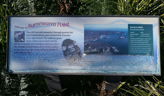
Image 2 - Information sign at Burrewarra Point

Image 3 - Map showing route from Batemans Bay to Gorilla Bay
The Walk: After stopping briefly to read the information sign, which I have to say, has seen better days, we commenced the walk on what was a beautifully shaded sandy track (Image 4). Surrounded by what was a small forrest and many Banksia trees, active with birdlife. You really do appreciate quickly, that this is a small sanctuary for both Flora and Fauna.
After enjoying the peaceful surrounds, we came to a small track that veered off to the left (only a couple hundred metres after the start of the walk). This leads to an old WWII concrete bunker. The bunker was built in the early 1940's as part of the east coast fortification against an expected Japanese attack. After the war had ended, these had no further use so were left in place, and now, are mainly visited by the odd walker, and of course, the inevitable graffiti vandals (Image 5). If you walk a little further past the concrete bunker, there is a break in the trees, and you get a wonderful view of the coastline to the north.
After returning to the track, we continued making our way through the shade of the sanctuary. The track meanders along the Gorilla Bay point, so it simply loops around back to the carpark, following the coastline. The first half of the walk is heavily forrested, and you don't get that many views of the ocean. That changes on the back section of the walk (just before looping back), where you will experience spectacular views (see slideshow of images at end of article).
On the first half of the path, I ducked off the path briefly to get a glimpse of the coastline. Only several metres from the track, I burst through the last of the trees and was met with spectacular views. However, I was also met with a spectacular cliff! Please be careful if you take children on this walk!


We did our walk just after the peak of the flowering Banksia season, but there were still enough flowers left to give you an appreciation of how beautiful it would be during the height of the Banksia flowering season (Image 6).
About halfway through the walk, there is another small track off to your left. If you follow this, it is only a short distance until you reach the lighthouse (Image 7). It is a fully automated lighthouse now, but there is also a survey marker nearby, and from here, you can get a fantastic view to the inland west (Image 8).
After returning to the track, we travelled only a short distance before the trees opened up and revealed a truly panoramic view of the coastline to the south (Image 1 top). There are some tremendous photo opportunities here (not just selfies!), so stop and take it all in (see gallery at bottom of article).
Image 4 - The sandy track at the start of the walk, meanders through a shaded forrest sanctuary
Image 5 - The concrete bunker, built during WWII

Image 6 - One of the last of the flowering Banksia flowers. This would be a spectacular walk when the Banksia trees are in full bloom.
We stopped at this spot for awhile, taking in the views and watching the waves crash against the rocks at the bottom of the cliff face. There was a gentle but warm breeze blowing in from the ocean, so it was really quite relaxing.
We dragged ourselves away, continuing the second half of the walk, which looped back into the sanctuary forrest. This section of the track comes back on itself, where you join the original track (turn left) taking you back to the carpark.
Although only a relatively short walk, it was very peaceful and relaxing. The views were fantastic, and if you're into flora and fauna, there's plenty for you to look at. This left me feeling relaxed and really happy that I'd done this walk.

Image 7 - The survey marker near the lighthousee

Image 8 - The view back inland from the lighthouse
 |  |  |  |
|---|---|---|---|
 |  |  |  |
 |  |