


Settlers Track
This is a wonderful ACT bushwalk with a great combination of historical sites and native landscapes. One of my favourites!
Walk Rating: Easy. Has some moderate inclines but mainly flat to undulating. 9 klilometres return.
Directions to Settlers Track
To get to the hut, drive to Tharwa. Once over the bridge, swing left onto Naas Road. From here it's around 50 kilometres to the carpark near Brayshaws Hut.
Please note that, after 36 kilometres, the road changes to dirt. It is a well-maintained dirt road but does get affected by the weather conditions from time to time. Generally, a two-wheel drive vehicle will have no problems but occasionally, the road is closed or only open to four wheel drives.
The map below (Image 2) is the outline of the Settlers Track walk. The carpark on your right side (if you are coming from Tharwa) is very well defined. Brayshaw's Hut is only about 100 metres from Boboyan Road, in a clearing. You shouldn't have any problems finding the location.
We arrived at the first historic site, the old sheep dipping yards. It was pleasing that parts of the old 'post and rail' fencing was still intact (Image 5) The information board at this location once again provided a great overview of the historical settlement of the immediate area and some background information about the acrtivities of the settlers.


Image 2 - Map of Settlers Walk and identified historical sites.
The Walk
After parking and walking the short distance to Brayshaws Hut, we were introduced to what conditions may have been like for the early settlers. The wind had picked up and, combined with overcast conditions, the weather was very chilly. Brayshaws Hut provided some temporary respite. but the gaps between the floorboards and wall boards ensured that the hut was penetrated by the chill. I'm sure the early settlers would have preferred to have their fire going most of the time!
The hut itself is wonderfully preserved. Ample signage provides information about the Brayshaws and their settlement in the area (Images 3 and 4).
After spending a short time at Brayshaws Hut, we were very keen to get walking and warm up. As we set off, my initial thoughts were that this would be one of those walks where conditions were not ideal and most of the day would be uncomfortable from the chill. My hands were already stinging from the cold - I cursed myself for forgetting to bring my gloves. But, fortunately, by the time we reached the wooded area of the first hill behind Brayshws Hut, the sky had cleared, the wind had dropped, and we were treated to a fabulous winter day. This was a great example of how quickly sub-alpine weather can change - fortunately in our favour this time.
The initial walk from Brayshwas Hut to the Waterhole Hut was across a well-maintained and visible track. The track has markers at regular intervals, so you don't lose your way. Along with the usual resident eastern grey kangaroos and red necked wallabies, we also spotted a large group of crimson rosellas, numerous yellow tail finches, as well as hawks and magpies.
After coming down the trail from the first hill, we were greeted by majestic views of the clearing, shadowed by the mountain ranges in the background. The peak of Sentry Box Mountain to the west was covered in snow. As the clouds began to clear, the contrast between the white snow and the deep blue of the sky was amazing. Nature at its best! (Image 1)

Image 1 -Settlers Track Walk and the snow covered peak of Sentry Box Mountain in the background.
Image 3 - Brayshaws Hut
We continued our walk towards Waterhole Hut. If you are on this walk and don't feel like walking the full nine kilometres, you will see a posted turn-point, which shortens the walk to six kilometres. Although the shortened walk takes you back past Westermans Hut, it does not take you to Waterhole Hut.
At Waterhole Hut we stopped for morning tea. It was beautuful to sit in the sun on a crystal-clear winter day. What a contrast with the chill we experienced when we commenced our walk.(Image 6) Waterhole Hut is another well-preserved structure. Although it is very basic, perhaps this reflects its intended purpose as a shelter or temporary stop-over for stock musters. (Image 7)
The hut itself has only a dirt floor but would nevertheless provide welcome shelter if you were caught out in a storm. There are sweeping views from to the immediate hillsides. In the distance, the peak of Boboyan Hill majestically overlooks the hut.

Image 4 - One of the many information signs that can be found on the walk describing the history of the early settlers.

Image 5 - An old post and rail fence between Brayshaws Hut and Waterhole Hut.

Image 6 - Enjoying the winter sun at Waterhole Hut
From Waterhole Hut, you begin to head back east on a four-wheel drive access road. The walk takes you through the wetlands, which were teeming with frogs on the day we were there. After the wetlands, your walk takes you through another pleasant forested area, before coming down into the clearing that takes you towards Westermans Hut. The route is dotted with old fence posts and remnants of the early settlers' grazing paddocks.
Coming out of the wooded area onto the clearing provided a panoramic view of Westermans Hut in the distance (Image 8)
The eastern grey kanagroos were clearly enjoying the winter sunshine. They took the opportunity to take in a few rays and attend to some personal grooming (Images 9 and 10).
Westermans Hut is perhaps one of the best preserved huts in Namadgi National Park (Image 11). The Kosciusko Huts Association have done a marvellous job in restoring and maintaining the hut. In the back section, perspex panels have been installed, partly to preserve the original mudbrick section of the homestead but also to provide the opportunity to see the structure in a preserved state (Image 12).

Image 9 - Eastern Grey Kangaroos lazing in the winter sunshine

Image 7 - Waterhole Hut with Sentry Box Mountain in the background

Image 8 - Westermans Hut
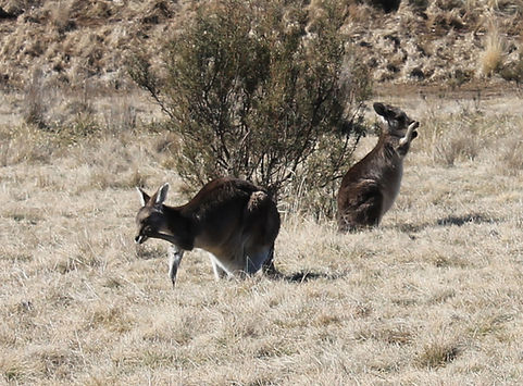
Image 10 - Some personal grooming!

Image 11- Westermans Hut

Image 13 - The fenced graves to the south east of the Westerman Homestead

After visiting the Westermans Hut, we walked the remaining two kilometres back to our starting point. Although we had spent nearly the whole day on the walk, we did feel as though we needed more time in order to fully take in the history of the huts and further explore the area. We will nevertheless return to this walk for that reason. It is a very intersting and rewarding walk, and I would recommend this to all.

Image 12 - The back part of the Westermans Hut with perspex covering, and preserving the original mudbrick

The view to the west across the clreaed grazing land of the Waterhole Hut area
Information signage at Westermans Hut