


Yankee Hat - Old Boboyan Road

Image 1 - The magnificent landscape of the Yankee Hat walk.
Yankee Hat is one of the many ACT bushwalks in and around the Old Boboyan Road. This is an easy and relaxing walk with lots of spectacular landscape and native wildlife, as well as ancient Aboriginal rock paintings.
Walk Rating: Easy, although take care on the really warm days as a large portion of the walk is through open plains and wetlands before reaching the forested area near the paintings. Six kilometre total distance.
Directions: To get to the Yankee Hat car park, you drive to Tharwa. Once over the bridge, swing left onto Naas Road. From here it's around 32 kilometres,so enjoy the beautiful picturesque scenery and the wonderful mountains! Continue on Naas Road until you pass the interesection with Apollo Road (leads to the old Honeysuckle Creek Tracking Station - another beautiful spot). From this point, Naas Road ends and Boboyan Road starts. Follow Boboyan Road and pass the turn-off to Orroral Valley and a little further on you will pass the Glendale Depot. This is a National Parks depot and services the needs of the rangers and Parks personnel with upkeep and maintenance of roads and infrastructure. Continue past the depot and go past the carpark at Rendezvous Creek. From here it is only a little further. Keep an eye out for the small sign (Old Boboyan Road) on the right side of the road. If the road changes from tar to dirt, you have gone too far! Turn off to the right and the well-maintained dirt road will take you to the Yankee Hat carpark. There are two small weirs to cross, but generally there are no problems with a two-wheel drive (except when the creek is in flood of course).

Image 3 - The first of the footbridges
The creek also has an abundance of insect life and dragonflies. After crossing the first footbridge, the track continues over open plains, passing through small forrested 'enclaves' before arriving at the base of the Yankee Hat Mountain, where the shade of the trees is a welcome respite on a warm day.
At this location there is another information sign that provides specific information regarding the Aboriginal rock paintings (Image 6). The walk from the sign to the rocks is only a further 100 metres or so (Image 7) and there is ample room to sit and relax and enjoy the surrounds and native birdlife.
The rock paintings provide great insight into the native history of the area, with the local Aboriginal people moving to the higher altitude areas to collect and eat the seasonal bogong moths.
The actual rock paintings are well preserved and possibly date back around 800 years (Image 8). According to the National Parks website, carbon dating of the nearby camp areas date back as far as 3,500 years.

Image 6 - Information sign near the Abopriginal rock paintings

Image 7 - The rock paintings are only a short distance from the sign

Image 2 - The start of the Yankee Hat walk
The Walk: Once you reach the carpark, you will see a large sign that provides information about the Yankee Hat walk. Beyond the sign, the start of the walking track is very inviting, with open plains and wetlands shadowed majestically by the nearby mountain of Yankee Hat and a little further to the south-west, Mt Gugenby (Image 2). The total distance of the walk is just over six kilometres return, so it's not arduous and very suitable for families.
After commencing the walk you will come across the first footbridge (Image 3), which crosses the Bogong Creek. It is worth a stop here as the population of native 'Welcome Swallows' are numerous and very active. These birds spend most of their time in swooping flight looking to catch insects. They rest for only very short periods and are therefore rather difficult to photograph! On this day, however, a pair of the birds had started construction of their nest underneath the foot bridge and sat still long enough for some photos (Images 4 and 5). These birds move so quickly that you don't appreciate their beautiful colours until you're lucky enough to get a photo of them when they're momentarily still.

Image 4 above and Image 5 below - Two Welcome Swallows commence constructions of their mudnest.

Image 5

After spending time at the site, we commenced our journey back to the carpark. We we're greeted by a Masked Lapwing, more commenly known as a Plover. These birds are none to happy when you come too close to their nesting site (which is on the ground). Luckily this fellow didn't come too close, prefering to make a lot of noise in flight before landing back near the nest site, seeming to be satisfied that a point had been made (Image 9)!
During the preceeding day, we had done other short walks in and around Old Boboyan Road. We were lucky enough to get reasonably close to a Wedgetail Eagle as it soared on the updrafts (Image 10). We also saw a fairly large and healthy looking Red Bellied Black Snake, which crossed the path of our group only 20 metres in front (well it is snake season).
Yankee Hat is such a pleasant walk and the area remains one of my favourites with the variety of tracks that you can walk and the abundance of wildlife always making for interesting times. I'd really recommend this walk.
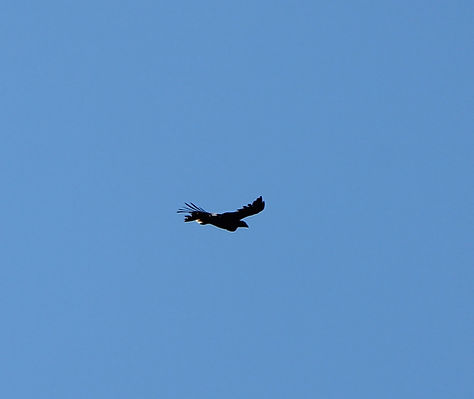
Image 10 - The Australian Wedgetail Eagle, one of the largest predatory birds in the world.
Image 8 - Aboriginal Rock Paintings at base of Yankee Hat

Image 9 - Masked Lapwing more commonly known as a Plover.

Image 11 - Snake season! Copperhead snake.